In posts on 2/20/09 and 2/26/09 I speculated about what is the real nature of a grid on the seafloor that some think is Atlantis. Since then I have taken just a little time to snoop around looking for other seafloor artifacts that may be related.
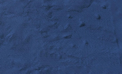
 This image shows the traces of seismic surveying located on the floor of the Gulf of Mexico, one of the most thoroughly surveyed regions of the sea floor. (click to see a larger image with more clear traces showing.) The survey was "3D Seismic", which records low-frequency sonic reflections from sub-seafloor rocks. The sonic data can then be used to calculate a three-dimensional model of the configuration of the rocks to a depth of several miles. It is a powerful exploration technique, and as you can see, it chews up the ocean floor rather thoroughly.
The location of this area is 28°45'N, 88°30'W, at a depth of 7,160 ft, or 2,180 m (By contrast, the "Atlantis" pattern is found at a depth of about 17,900 ft, or 5,460 m). Considering that the area shown is about 50 miles wide by 30 miles north-south, the traces are about a half mile apart.
If the "Atlantis" pattern is a sonic survey of some kind, it is much looser, and the source was quite a bit more energetic. Possibly whoever did it was looking for much deeper targets than what is shown here in the Gulf.


No comments:
Post a Comment